Logo Alexandre Neto
  • Home
  • About
  • Services
  • Recent Posts
  • Posts
  • Plugins
  • English
    Português English
  • Dark Theme
    Light Theme Dark Theme System Theme
Logo Inverted Logo
  • Posts
  • Opinion articles
    • Giovanni had an itch...
    • Welcome note
    • Open Source, why?
  • Plugins
    • Multipart Split
    • Walking time
  • News
  • Tutorials
Hero Image
Giovanni Had an Itch... an Open Source Development Tale

Once upon a time, there was a man called Giovanni (totally fictional name, by any means related to NaturalGIS’s CEO and Open Source advocate, Giovanni Manghi). He was a daily QGIS power user and he loved the software, but he had an itch… Something was troubling him. As any other main character of the traditional tales, instead of looking away, he decided to accept the quest and solve it. 
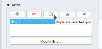
This itch of his was about the QGIS layout grids. It used to take Giovanni about 10 minutes to create a nice grid for a map layout, and then, another 20 minutes to replicate it a few times for different scales with small variations. If he had to do this operation one or two times every week, at the end of the year, he would have lost up to 34 hours of his precious and very limited time.

  • QGIS
  • Open Source
Tuesday, December 31, 2024 | 3 minutes Read
Hero Image
Create a PyQGIS Development Environment Using Conda and VScode

As a self-taught PyQGIS developer, one of my main hurdles has always been to prepare the development environment for PyQGIS. An environment that allow me to run PyQGIS scripts, helps me code faster by providing PyQGIS highlighting and autocompletion, enables me to debug my plugins and scripts as they run, etc… I have been a user (and even a… “cof cof”… maintainer) of the QGIS packages for conda provided by the conda-forge community. In Linux, it has allowed me to easily install the LTR version of QGIS (or any other version) alongside the most recent QGIS version provided by qgis.org apt repositories. I ended up finding that this was quite convenient for development too.

  • pyqgis
  • QGIS
  • conda
  • vscode
Saturday, May 11, 2024 | 6 minutes Read
Hero Image
Configure editing form widgets using PyQGIS

As I was preparing a QGIS Project to read a database structured according to the new rules and technical specifications for the Portuguese Cartography, I started to configure the editing forms for several layers, so that: Make some fields read-only, like for example an identifier field. Configure widgets better suited for each field, to help the user and avoid errors. For example, date-time files with a pop-up calendar, and value lists with dropdown selectors. Basically, I wanted something like this:

  • pyqgis
  • QGIS
  • Recart
Monday, September 30, 2019 | 4 minutes Read
Hero Image
Using QGIS from conda-forge

QGIS recipes have been available on Conda-forge for a while, but now, that they work for the three main operating systems, installing QGIS from Conda is s starting to become a very reliable alternative to other QGIS distributions. Anyway, let’s rewind a bit… What is Conda? Conda is an open source package management system and environment management system that runs on Windows, macOS and Linux. Conda quickly installs, runs and updates packages and all their dependencies. Conda easily creates, saves, loads and switches between environments on your local computer. It was created for Python packages, but it can package and distribute software for any language. What is Conda-forge?

  • conda
  • QGIS
  • conda-forge
  • mamba
Wednesday, May 29, 2019 | 6 minutes Read
Hero Image
QGIS Top Features 2016

A year ago I have asked QGIS’s community what were their favourite QGIS new features from 2015 and published this blog post. This year I decided to ask it again. In 2016, we add the release of the second long-term release (2.14 LTR), and two other stable versions (2.16 and 2.18). 2016 was again very productive year for the QGIS community, with lots of improvements and new features landing on QGIS source code, not to speak of all the work already in place for QGIS 3. This is a great assurance of the project’s vitality.

  • QGIS
Thursday, January 5, 2017 | 4 minutes Read
Hero Image
QGIS Features I long for while using ArcGIS

(aka Features that ArcGIS Desktop users might not know that exists) From time to time, I read articles comparing ArcGIS vs QGIS. Since many of those articles are created from an ArcGIS user point of view, they invariably lead to biased observations on QGIS lack of features. It’s time for a QGIS user perspective, so bare with me on this (a bit) long, totally and openly biased post. "Hello, my name is Alexandre, and I have been using... [QGIS](http://www.qgis.org)" This is something I would say at an anonymous QGIS user therapy group. I’m willing to attend one of those because being recently and temporally forced to use ArcGIS Desktop again (don’t ask!), I really really really miss QGIS in many ways.

  • ArcGIS
  • Opinion
  • QGIS
Thursday, January 28, 2016 | 11 minutes Read
Hero Image
QGIS Top Features 2015

With the release of the first long term release (2.8 LTR), and two other stable versions (2.10 and 2.12), 2015 was a great (and busy) year for the QGIS community, with lots of improvements and new features landing on QGIS source code. As a balance, I have asked users to choose wich were their favorite new features during 2015 (from the visual changelogs list). As a result I got the following Top 5 features list.

  • QGIS
Friday, January 1, 2016 | 3 minutes Read
Hero Image
Getting multipolygon vertexes using PostGIS

Today I needed to create a view in PostGIS that returned the vertexes of a multi-polygon layer. Besides, I needed that they were numerically ordered starting in 1, and with the respective XY coordinates. It seemed to be a trivial task – all I would need was to use the ST_DumpPoints() function to get all vertexes – if it wasn’t for the fact that PostGIS polygons have a duplicate vertex (the last vertex must be equal to the first one) that I have no interess in showing.

  • Postgis
Friday, November 6, 2015 | 2 minutes Read
Hero Image
Hack to adjust map symbols location in QGIS

Now and then I get too many map symbols (points) in the same place, and I thought how nice it would be if we could drag n’ drop them around without messing with their geometries position, just like we do with labels. That thought gave me an idea for a cool hack. Choose your point layer and start by creating two new fields called symbX and symbY (Type: Decimal number; Size: 20; Precision: 5). Now go the layer properties and in the Style tab edit your symbol. For each level of your symbol select “map units” as the offset units, and set the following expression in the offset data define properties option:

  • Cartography
  • Hint
  • QGIS
Monday, February 23, 2015 | 2 minutes Read
Hero Image
Calculate polygon centroid's coordinates

I had the need to add columns with the coordinates of polygons centroids. I came up with the following expressions to calculate X e Y, respectively: [code] xmin(centroid($geometry)) ymin(centroid($geometry)) [/code] The expression seems quite simple, but it toke me some time before I realize that, not having a x(geometry) and y(geometry) functions, I could use the xmin() and ymin() to get the coordinates of the polygons centroids. Since this wasn’t the first time I had to use this expressions, this post will work as a reminder for the future.

  • Hint
  • QGIS
Tuesday, February 10, 2015 | 1 minute Read
Hero Image
Labels leading lines with QGIS and Postgis

Recently I had the need to add labels to features with very close geometries, resulting in their collision. Using data-defined override for label’s position (I have used layer to labeled layer plugin to set this really fast) and the QGIS tool to move labels, it was quite easy to relocate them to better places. However, in same cases, it was difficult to understand to which geometry they belonged.

  • Cartography
  • Hint
  • Postgis
  • QGIS
Monday, January 12, 2015 | 2 minutes Read
Hero Image
Multiple format map series using QGIS 2.6 – Part 2

In my last post, I have tried to show how I used QGIS 2.6 to create a map series where the page’s orientation adapted to the shape of the atlas features. This method is useful when the final scale of the maps is irrelevant, or when the size of the atlas elements is similar, allowing one to use a fixed scale. On the other hand, when using a fixed scale is mandatory and the features size are too different, it is needed to change the size of the paper. In this second part ot the post, I will try to show how I came to a solution for that.

  • atlas
  • Map composer
  • QGIS
Tuesday, November 18, 2014 | 4 minutes Read
  • ««
  • «
  • 1
  • 2
  • »
  • »»
Navigation
  • About
  • Services
  • Recent Posts
  • Plugins
Contact me:
  • srnetochan
  • Alexandre Neto
  • @alexnetogeo
  • @alexnetogeo

Toha Theme Logo Toha
© 2022 Copyright. Globe icon created by Freepik - Flaticon
Powered by Hugo Logo